[wpdevart_countdown text_for_day=”Days” text_for_hour=”Hours” text_for_minut=”Minutes” text_for_second=”Seconds” countdown_end_type=”date” end_date=”28-06-2024 10:00″ start_time=”1553508107″ end_time=”0,1,1″ action_end_time=”hide” content_position=”center” top_ditance=”10″ bottom_distance=”10″ ]Race Is ON![/wpdevart_countdown]
[su_button url=”https://macmacultra.com/?post_type=product&p=4967&preview=true”]ENTER HERE[/su_button] | [su_button url=”https://macmacultra.com/product/payment-plan-200-miler-entry-deposit-3/”]PAYMENT PLAN[/su_button]
[su_tabs]
[su_tab title=”Quick Facts” disabled=”no” anchor=”” url=”” target=”blank” class=””]
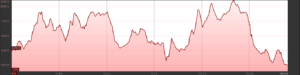
The quaint old gold mining town of Pilgrim’s Rest is the starting point of your epic journey.. The history of gold mining operations in the Pilgrim’s Rest area goes back more than 160 years to the 1840’s. The gold rush began in 1873 when the Lydenburg magistrate advised the Transvaal Volksraad that gold had been discovered in the streams. Hundreds of diggers from as far afield as Australia, America, England and France flocked to the gold-fields to make their fortune. The trail passes many relics from these early days of mining as one climbs away from the start of the trail.
![]()
Mac Mac Ultra is registered as a UTMB® INDEX RACE.
[embedyt] https://youtu.be/56_pzTfJhQs?si=SQ0i9pBzg7W0-Vvu[/embedyt]
[embedyt] https://www.youtube.com/watch?v=-0L8cOJkkVI[/embedyt]
[embedyt] https://www.youtube.com/embed?listType=playlist&list=PLyPEr2W6m9aW3uwJdB7-limdXwskmV4s2[/embedyt]
100Miler
Quick Facts:
[/su_tab]
[su_tab title=”Course” disabled=”no” anchor=”” url=”” target=”blank” class=””]

100Mile
Trail Section 1.
Pilgrims to Mac Mac Hut
Description:
Gold was discovered in 1872, six hours by horse from Lydenburg, by Thomas Mclachlan and partners. This triggered the first gold rush in South Africa and diggers from all over started to flock to what later became Mac-Mac. Alex “wheelbarrow” Patterson left Mac-Mac to prospect and in September1873 discovered the rich gold deposits in the Pilgrim’s Creek
The quaint old gold mining town of Pilgrim’s Rest is the starting point of your epic journey.. The history of gold mining operations in the Pilgrim’s Rest area goes back more than 160 years to the 1840’s. The gold rush began in 1873 when the Lydenburg magistrate advised the Transvaal Volksraad that gold had been discovered in the streams. Hundreds of diggers from as far afield as Australia, America, England and France flocked to the gold-fields to make their fortune. The trail passes many relics from these early days of mining as one climbs away from the start of the trail.
Distance:
68km
Ascent:
3900m
Descent:
2970m
Technicality:
Moderately steep climb at start, from there on, rolling hills to the finish. Open grassland escarpment running over boulder fields, as well as some forest sections with beautiful soft undergrowth. Some Rocky single track trail.
Scenery:
Lush indigenous Forest down below and Boulder fields on the escarpment with Clivia forests at lower altitudes. Beautiful views looking down the escarpment over the Lush Lowveld. Breathtaking views of the Crystal Springs Nature Reserve.
Fauna And Flaura:
Massive Indigenous trees. Endangered High altitude Grassland. Wild flowers with indigenous ferns and clivias. Wildlife such as Bushbuck , Duiker , Reedbuck, warthog, bush pig and Baboons. Keep your eyes open for the beautiful birdlife that can be spotted in the lush forests. The Purple Crested Turaco is a bird that should not be overlooked, as it’s colours are as vibrant as the Lowveld itself! With a bit of luck Fish Eagle spotting’s can also occur now and then.
Pilgrims Rest to Mount Sheba:

A truly unique start to your 100Miles: A neutral zone run, joined by family and friends, from Down Town Pilgrims to Upper Town Pilgrims and back(+-2km). Experience the town of Pilgrims and its people, sending you off on your adventure. Back at The Vine it is a small climb out of town then dropping down and crossing the Blyde river were your ascent starts on some plantation roads and before you know it you are in the indigenous rain forest of Mount Sheba. Mount Sheba Resort is your first checkpoint and also a spectators point. Great place for your supporters to settle in and wait for your return later on.
Distance:
13.5km
Ascent:

780m
Descent:
360m
Mount Sheba:
Spector Point:
Yes – Mount Sheba
Cut off:
No
Drop bag:
No
Mount Sheba to Morgenzon

A little ‘climb/hill/koppie’ out from Mount Sheba Resort through a beautiful rain forest. Trail makes a turn on the escarpment with Pilgrims in the distance. Descending through some old plantations to join a small peace of trail on grassland hills leading to Morgenzon Aids Station.
Distance:
15.1km

Ascent:
1000m
Descent:
1055m
Morgenzon Forest Station
Spector Point:
Yes – Morgenzon Forest Station
Cut off:
No
Drop bag:
No
Morgenzon to Morgenzon:

From Morgenzon forest station runner first cross Clewer stream joining the old Robbers Pass, an old trade route to Pilgrim’s Rest from Lydenburg. Descending to Clewer Falls before a steep climb in a beautiful indigenous forest with a crystal clear stream, lots of Clivias and Ferns , until it joins up with the old wagon path. Another decent into the valley before climbing past some waterfalls. Fast section on plantation roads dropping back to Morgenzon Checkpoint.
Distance:
13.4km

Ascent:
990m
Descent:
990m
Morgenzon Forest station:
Spector Point:
Yes
Cut off:
Yes 24h00 Friday
Drop bag:
No
Morgenzon to Mount Sheba:

This is an exiting new section to the 100 and 200 miler. A steady climb trough Pine plantation to get to the top of the escarpment. Most runners will reach this section at dusk for a spectacular first sunset. After some running on the escarpment you start descending slowly into a valley passing rock formations that looks like Mount Sheba’s own Lost City. The trail joins a small stretch of tar road dropping into Mount Sheba Hotel and Resort for the Mexican Party Checkpoint .
Distance:
16km

Ascent:
720m
Descent:
670m
Mount Sheba
Spector Point:
Yes
Cut off:
Yes Saturday morning 02h00
Drop bag:
No
Mount Sheba to Mac Mac Hut

A short single track section trough Mount Sheba’s Rain Forests and down into the Blyde river valley. This section connects the Prospectors trail with the Fanie Botha Trail. Nice flowing forestry road takes you to Mac Mac Hut for the first time. Although it is a runnable road, the steady climb hampers running at a fast pace.
Distance:
11.7km

Ascent:
400m
Descent:
490m
Mac Mac Hut
Spector Point:
No
Cut off:
No
Drop bag:
Yes – First Time
100Mile
Trail Section 2. Mac Mac Hut to Merry Pebbles
Mac Mac Hut to Graskop Hut:

After sampling all Ouma’s stash in your drop bag you will head out on an old section of the Fanie Botha hiking trail not in use anymore towards Graskop. This section starts with some forestry road leading into a single track climb into the open with a view of Graskop and Gods window in the distance. Dropping down towards Graskop you must take caution crossing the Pilgrims/Graskop/Sabie road. A short forest run and you’re at Graskop Hut were the 50milers will have their start at 05h00 Saturday.
Distance:
13.9
Ascent:

400m
Descent:
580m
Graskop Hut
Spector Point:
No
Cut off:
16h00 Saturday
Drop bag:
No
Graskop is a small town in Mpumalanga province, South Africa. It was set up in the 1880s as a gold mining camp but it now serves as a tourist destination and the timber industry. The name is Afrikaans for grassy hillock. “God’s Window”, a scenic view from the escarpment of the Lowveld below, is located outside the town.
Graskop is 14 km south-east of Pilgrim’s Rest and 28 km north of Sabie. It was laid out between 1880 and 1890 on a farm belonging to Abel Erasmus, Native Commissioner of the Transvaal Republic. Named after a grassy hillock (Afrikaans gras, ‘grass’, kop, ‘hillock’). Originally it was a mining camp. It is the best place to view the “Edge of the Lowveld”, with a sudden drop of 700m
Graskop Hut to Mac Mac Pools

The first 8km will be a combination of free-flowing jeep and single track, to get the legs warmed up nicely, before a big drop into an amazing indigenous forest. At the bottom of the valley you will cross the Mac Mac river and start your climb back up to the first check point at Mac Mac pools
Distance
12.8km

Ascent:
600m
Descent:
650m
Mac Mac Pools
Spector Point:
Yes – Mac Mac Pools
Cut off:
No
Drop bag:
No
Mac Mac Pools to Mac Mac Hut

After a refreshing stop and seeing your supporters you will make your way down to Mac Mac falls. The 65 m high Mac Mac Falls, in the Mac Mac River, is a declared National Monument. This waterfall was originally a single stream, but gold miners blasted it with dynamite to divert the river in an attempt to work the rich gold-bearing reef over which it plunges. A short 7.5km through plantations and a steep single track forest section will bring you to the next Aid Station at Mac Mac hut.
9.9km

Ascent:
480m
Descent:
245m
Mac Mac Hut
Spector Point:
No
Cut off:
16h00
Drop Bag
Yes second visit
Mac Mac Hut to Stables

If you thought you’re on top and done climbing think again this section has the most ascents on the route. At Mac Mac hut you will continue you’re really nice single-track climb. Weather depending, you should have spectacular views of the Graskop escarpment and Gods Window. Up and over you will descent into the Tweefontein valley with a small river, rockpool and waterfall. The trail ascends op the ridgeline overlooking beautiful Sabie valley. Once on the ridgeline you will have the amazing view of Mount Moody, at that point you will ask yourself, are we going over that mountain? Once over the mountain you will join an easy rocky runnable jeep track that ends with the Stables checkpoint.
16.3 km

Ascent:
1020m
Descent:
831m
Stables Hut:
Spectator point
No
Cut off
20h00
Drop Bag
No
Physio:
Most likely
Stables Hut to Mt Anderson Split

After the party at Stables, up a short jeep track section that sends you down a spectacular single track that leads on to Hartebeesvlakte. This is truly one of the world’s hidden beauties. Here you should keep your eyes open for Hartebees, White-tailed Gnus, Burchell’s Zebras, Blesbok and perhaps a Leopard if you are lucky. Once over the Hartebeesvlakte you will then pass close to the summit of Mount Anderson via jeep track that peaks at an altitude of 2284 Meters, then around to the top of the escarpment.
14.9km

Ascent:
735m
Descent:
617m
Mt Anderson Split
Spectator point
No
Cut off
No but Compulsory Medical Check has to be passed
Mt Anderson Split to Maritzbos Hut

Now we are getting to the business end of things, you should welcome some downhill. Some call it the Towerbos or Magic Forest others call it Pain forest. A super steep slippery wet descent to Maritzbos that never ends. Some will also go down there in the dark. This section is a real gem of 6km indigenous forest, rivers, rock pools and the most spectacular waterfalls. You will cross several streams on slippery wooden bridges. The final stretch flattens out till you get to the Party at Maritzbos aid station
6.2km

Ascent:
290
Descent:
900m
Maritzbos Hut
Spector Point:
No
Cut off:
06h00
Drop Bag
No
Maritzbos Hut to Ceylon Hut

The first section between Maritzbos and the Ceylon Hut is a runnable 8.7 km jeep track section with one or two climbs to negotiate. At Ceylon hut you can almost see the end, and this is where you are going to start swearing at the RD
8.7km

Ascent:
250m
Descent:
466m
Ceylon Hut
Spector Point:
Yes
Cut off:
08h00
Drop Bag
No
Ceylon Hut to Merry Pebbles

This is a real tester for the mental training you have done over the past year. Steady jeep tracks climb to the top of the “The Why the F” koppie aka ‘Frikkie’s Folly’. A really spectacular descent on a MTB single track brings you to the bottom were you will follow the Sabie river, one more river crossing and a cold Sabie Brewery beer awaits you at the finish.
9.5km

Ascent:
320m
Descent:
380m
[/su_tab]
[su_tab title=”Compulsory Equipment” disabled=”no” anchor=”” url=”” target=”blank” class=””]
Compulsory Equipment
[/su_tab]
[su_tab title=”100 Mile Zama Zama’s” disabled=”no” anchor=”” url=”” target=”blank” class=””]
100 Mile Zama Zama’s
[/su_tab]
[/su_tabs]


